
The Roman road through Chalfont St Giles.
The only real investigation on the ground was carried out in the early 1960s by a group of people who called themselves "The Viatores". Their results were published in a book "The Roman Roads in the South-East Midlands" published by Gollanz 1964. An extract of what they found along the line of the road through Chalfont St Giles is as follows:
"For the next 1200 yards to the south-west, the alignment is marked by the course of Vache Lane, which in the middle third of its length exactly coincides (with the alignment). There are no signs of metalling in the overgrown banks of the Lane, but comparatively recent widening would have disturbed any remaining metalling. In its final third, Vache Lane descends a hill to Chalfont St. Giles in the valley of the River Misbourne, where there are several suggestive place-names.
The modern road goes slightly to the north of the true alignment, which passes through the grounds of The Pheasant Inn, just south of the cross-roads between Vache Lane and the Amersham-Uxbridge road. The houses at the cross-roads are known as Street End, and most of the old buildings and walls in Chalfont St. Giles are built on a foundation of sarsens, which might have been used by the road.
The alignment crosses the River Misbourne, passing a few yards to the south-east of St. Giles' parish church at SU 991935, and intersects Bowstridge Lane without surface indication. Signs of the road are seen next to the south-west of Bowstridge Lane at SU 990934, on the southern slope of the dry valley at the bottom of which is the Deanway. By means of a terrace-way, it proceeds diagonally along and up the hillside. The terrace, up to 30 feet wide, may be seen in the orchards above Stonewell's Farm and in the field above Milton's Cottage; it may also be discerned indistinctly in the next field before it disappears under the recent building developments in the area of Narcot Lane.
The alignment continues south-westerly for nearly 1 1/2 miles before the next surface indication of the road is seen. A projection south-west of the terrace-way up the south side of the dry valley would, however, come to a high point, 354 ft above O.D., on Narcot lane at SU 984929. The angle of the terrace-way would seem to indicate that the alignment followed by Vache Lane subsequently turned slightly to the west in order to negotiate the dry valley. This high point would have been the obvious place from which the road could resume its former course."
The line of this road has been plotted onto an 1890 map of the country around Chalfont St Giles. This will open in a separate window. Use your Back button to return to this page.
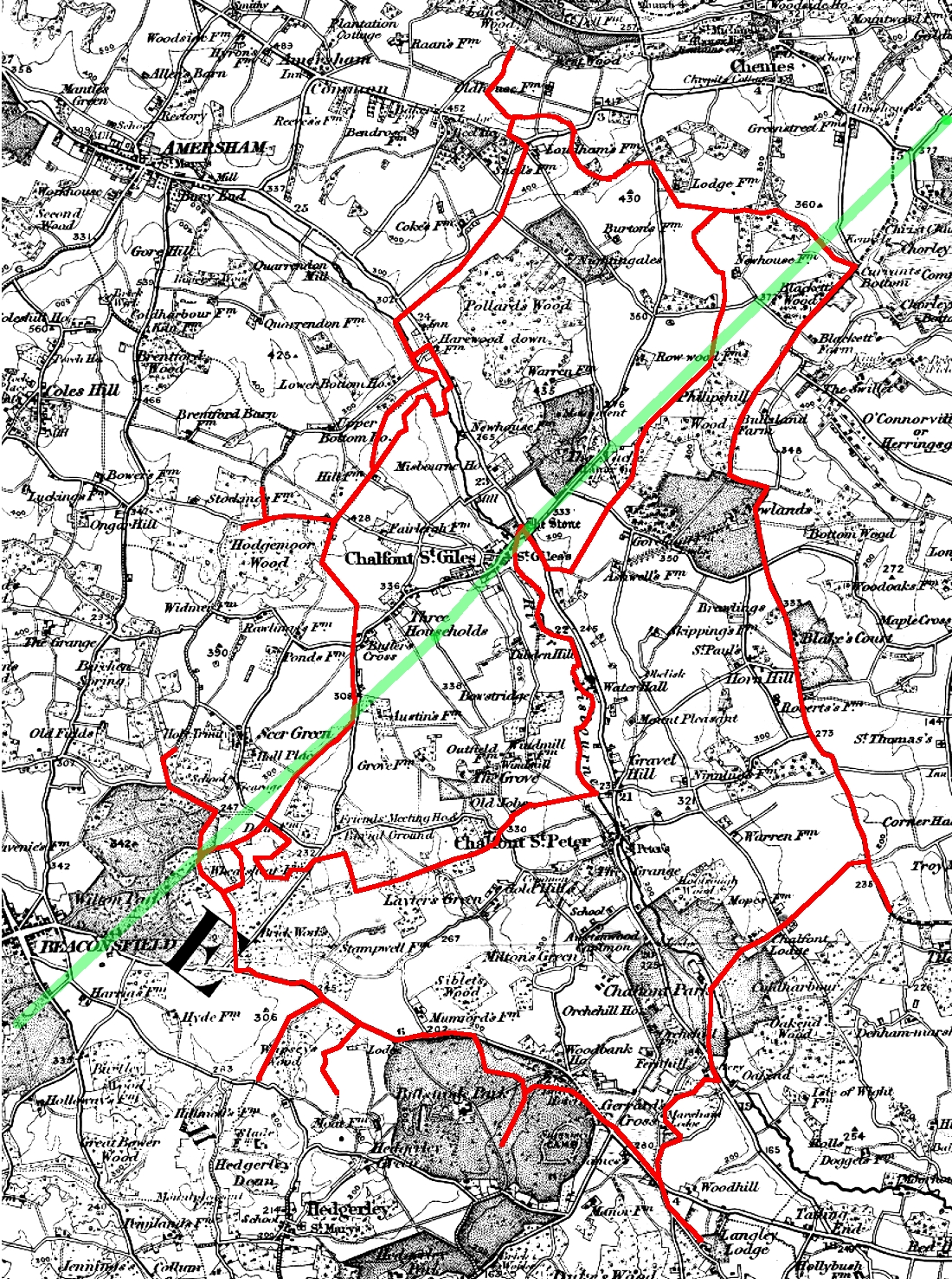
A circumstantial case for this road is that a direct road linking the two major Roman towns at St Albans and Silchester is a logical probability, and would enable the inhabitants of the Roman Villas along the Chess, Misbourne and Wye valleys to access those towns. This is supported by the evidence in ancient Deeds for land in the village, which refer in 1407 to "the highway from Bekensfeld to St Alban's", and in 1474, to "the great highway or street from Isnamstede Cheyne toward Bekensfeld." (His. Man. Comm. 15th Report pp130/1.). The terminology used is indicative of a road of Roman origin.
More evidence for the existence of this road can be found in the Chalfont St Peter Manor Court Roll of 26 October 1540. (BRO D/BASM/15/9/e.)
In this entry Edward Restwold (Lord of Vache Manor) acknowledges holding lands in Chalfont St Peter Manor. These lands are clearly what is now the Roughwood Estate. The Roman road ran through the middle of these lands and the Court Roll refers to lands "previously Stephen atte Feld called Luppefeld beside le Portestrete".
Using Gelling on meanings of placenames ("Signposts to the Past" 1988) le Portestrete would probably mean "the road to the market town".
The 1840 Tithe Survey shows a field called Porters Field with in the Roughwood lands and astride the line of the road. This could a derivation from le Portestrete
The line of the road described above takes it through the churchyard and could therefore be the reason why St Giles Church is located where it is. Where the road crosses the Misbourne is possibly the site of a pagan shrine to a water god or spirit. When Christianity first spread it took over and utilised such pagan sites.
REFERENCES. Unless otherwise specified, all references given above refer to catalogue references at the Centre for Buckinghamshire Studies at Aylesbury. (County Record Office.)
This print is a section of the Chalfont History website.
Please come back soon.
John Dodd ©2012 www.chalfonthistory.co.uk