
Nightingales
Nightingales was probably an ancient habitation site and was just a relatively small farm holding until, in 1828, it was turned by a John Mair into a large country house within a park. He and his descendants retained it for 100 years and stained-glass windows and monuments in Chalfont St Giles Church commemorate the family, the Mairs and Hadens. In the 1930s Nightingales was broken up into a number of large building plots.
Revised 10 Oct. 2006 based on substantial new information about its early history.

We don't know why this area was called Nightingales. Whilst it is conceivable it could be because there were lots of these birds in the locality, it is much more probable that it was because some of the land was once owned by someone called Nightingale. There were certainly people in the area with that surname in the 13th to 16th centuries (Reference G Elvey notebooks at BAS.) Also a "Henry Nytingale" is mentioned in the Chalfont St Peter Manor Court Rolls in 1558. However no documentary evidence has appeared to link anyone of that name to this particular site. The name Nightingales for some of the fields can be traced back to 1608 (D-X 1742) but for the farm it first appears in the records in 1812 (OS Surveyors Drawings). Nightingales Lane clearly must be so called because it leads to that land holding but we see from Vache Deeds that in the early 1800s the road was called Chesham Lane.
The earliest firm documentary evidence so far discovered for the extent and ownership of the land that became Nightingales, is in a series of Deeds recently deposited at the Centre for Bucks Studies under reference D-X 1742. The earliest of these Deeds is dated 10 June 1453 when a Thomas Portreve, probably of Colnbrook, sold some of the land to Edmund Brudenell who was a major landholder in Chalfont St Peter and Amersham. His descendant John Brudenell sold or leased some of the land to Ralph Moreton in 1601 but more importantly all the land was sold by Sir Basyl Brookes of Maderly Court to Ralph Moreton on 18 November 1608. He also sold Burtons Farm to others on the same day, (ref D/BASM/Z/51). The Deed lists all the fields including Nightingales together with "the messuage where Ralph Moreton dwells".
(Sir Basyl Brookes is the famous ironmaster of Coalbrookedale and he obtained the land in Chalfont St Giles through marriage to Etheldreda Brudenell, a daughter of Sir Edmund. It is interesting to note that there are Moretons in the same area of Shropshire although no family link has been found to the Brookes. Ralph Moreton was clearly living in Chalfont St Giles at the time of the sale and from the PCC Wills Index there are other Moretons in the Amersham area at the same time. The name Moreton almost certainly evolved to Morton and the later members of this family appear in other subjects on this site.)
The property remained in the hands of the Moreton family until 30 April 1700 when a complex arrangement was set up to "dock the estate tail" and allow it to be inherited by a daughter Sarah who was married to Richard Bovington. Under her married name she sold the property on 28 Sept 1721 to George Abbott although she leased for herself a part of the house. George Abbott presumably died leaving an heir, Robert, since that name appears as the owner in a Deed {D-CH/A/3-4). Presumably the Abbotts did not farm the land as this same Deed mentions a tenant, Joseph Boddy. In 1750 on 17 September Jane Abbott, widow, and George Abbott (probably a son or grandson of the original George) sold the land to Isaac Eeles of Cokes Farm, the adjacent property.
The next event is dated 1787 when Kender Mason Esq. of Holborn acquired Cokes Farm, "Abbotts" Farm, and a lot of other land from the estate of Isaac Eeles and others. The property he bought formed the Beel House Estate (D-CH/A/3-4). The fields that made up Abbotts Farm are listed and they include "Nightingale's Closes" as well as other fields that are listed in earlier Deeds. Some of these names still appear many years later in the 1840 Tithes Record where they are shown on either side of what had become the "Nightingales" Estate of John Mair. We can be certain that Abbotts and Nightingales are successive names for the same landholding from the evidence of the field names, plus our knowledge of the ownership of the land at each end of the Nightingales Estate. In addition we have the evidence of continuity of ownership and occupation from the Land Tax records.
The Assesment for the Chalfont St Giles Parish Poor Rate for 1771 lists "Abbats" as being held or occupied by Joseph Saunders. (Quoted by W Adams Clarke in "A History of the Parish Church of St Giles". 1961)
The map below shows in green the probable extent of Abbotts Farm. The brown area is Snells Farm owned by the Wingfield family until 1787. The map is based on the 1840 Tithe Map but has the additional field boundaries that appear on the 1812 OS Surveyors Drawings shown in red.
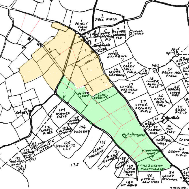
The land of Abbotts Farm runs alongside the Vache Estate and lies between the Vache and the lands of Lowdhams Farm. At one time all Abbotts Farm land must have fallen within the Manor of Chalfont St Giles, which was based on the Vache, but it must have gone out of the Manor prior to 1453.
There is one intriguing facet of the location of the farmstead of Nightingales/Abbotts and that is its layout in relation to the layout of the three enclosures called Doggets. It is this relationship, which leads me to surmise that Nightingales/Abbotts is an ancient site. See the Doggets page.
The Kender Mason estate was soon broken up and Abbotts Farm was sold on 22 March 1793 to Samuel Boddy and he and his family held the land until 25 March 1812 when it was sold to a William Osborne who was a Chairmaker of Wardour Street, St James, Westminster. He took out a mortgage in 1813 from a Richard Ware of Chesham. John Mair appears in the picture in 1816 because on the 19 March he paid Richard Ware £520/19/9 to have the mortgage on "Nightingales Farm formerly Abbotts Farm" assigned to him. William Osborne was clearly in financial trouble. He owed money to a stockbroker Josiah? Hunt as well as having the mortgage. He was in the custody of the "Marshall of the Marshalsea", a debtors prison where he died before judgment was made on 3 September 1816 in favour of John Mair who was also suing him for debt. This appears to account for how John Mair eventually acquired Nightingales and why no sale notice for the estate has been found. (D-X 1742)
There is however one as yet one unexplained fact. In 1822 the Chalfont St Giles Land Tax Returns list Nightingales as in the ownership and occupation of a William Priest. Whether he owned it outright or whether John Mair retained an interest has not been determined. However four years later in 1826 the Land Tax Returns show John Mair as the owner and William Priest as occupier.
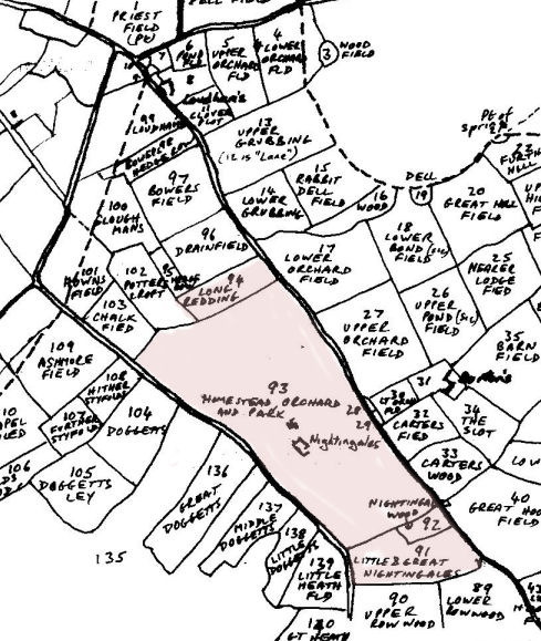
When John Mair acquired the land it was a collection of enclosed fields with a farmstead named Nightingales, as we can see from the initial Ordinance Survey drawings made in 1812. As noted above the detail circumstances of this purchase and the building of the new house are not clear. However we do know that by 1840 the house had been built and the internal field boundaries had been done away with so as to form a Park. The farmstead looks as if it was turned into stabling and staff quarters and we can follow the changing occupants of the main house and the old farmstead from the ten yearly National Censuses beginning in 1841. The map below is the 1840 Tithe Map with the Mair estate in red.
When John Mair died in 1848 the estate came into the hands of his widow and then descended to his daughter Sarah and her husband The Rev. John Clarke Haden and then to their children. (See the separate page for the History of the Mair and Haden Families.)
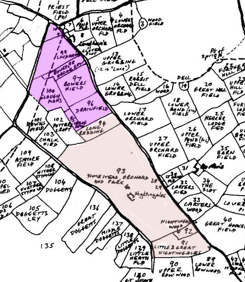
At some time, probably in 1859 when Snells Farm came up for sale, the Mair family purchased a block of land to take their boundary up to the current Cokes Lane and its junction with the Amersham Road.
The estate remained in the hands of the Haden family until 1923 when the then owner, Algernon Haden, sold the estate. He was obviously a family member but his relationship has not been established. The sale was a curious affair. Haden gave the sitting tenant at Nightingales Farm, Charles Mead, first refusal. Mead immediately contacted Frederick Long who was living at Cokes Farm probably knowing that Frederick Long, together with his father Charles Long and his brother James Long were active property developers in the area. They all came to an arrangement where Mead would buy the estate, the Longs would buy it from him for £2,000 and would then sell back to Mead the farmhouse and 24 acres of land for the sum of £4,800. On the surface, this does not make sense, yet this is what Charles Long records in detail in his account book (D 716/1). Plans were then prepared to break the property up into a series of building plots. Although the detailed plan proposed by Long in D716/2/1 was not followed exactly, the eventual development was very similar.
The situation following the sale in 1923 is recorded on a revised Tithe Apportionment dated 26 November 1925 (DX 1226/10).
William Esplin Stewart purchased the main house and 14 acres of ground running across from Nightingales Lane to Burtons Lane.
The land where the shops now stand between Burtons and Cokes Lanes, plus the ground just to the south where Nightingales Cottage stood and where a recent development (The Hawthornes) has taken place, remained in the possession of Haden.
The 44 acres of land between the Haden land at Little Chalfont and Nightingales House were acquired by F J and C Long and were used to develop Burton's Way, Birkett Way and Park Grove.
The Longs also acquired 27 acres of land at the other end of the Nightingales Estate (91 on the map). This was eventually split into a number of very large building plots.
Between this land (91) and Nightingales House lies the old Nightingales Farm. The Farm buildings and 24 acres of land were acquired by Charles Mead.
There was a further revision to the Tithe Apportionment dated 7 July 1931 (DX 1226/20) which showed how the land purchased by Long and the other purchasers was subdivided into a series of building plots which form the basic pattern we see today. This Apportionment document lists the names of all the original purchasers of each plot.
The history has not been traced any further.
REFERENCES. Unless otherwise specified, all references given above refer to catalogue references at the Centre for Buckinghamshire Studies at Aylesbury. (County Record Office.)
This print is a section of the Chalfont History website.
Please come back soon.
John Dodd ©2012 www.chalfonthistory.co.uk